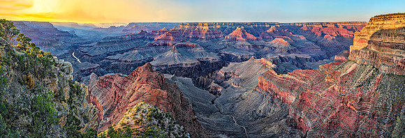
Feeling the Abyss at Mohave Point ; aka Mother Natures Crayon Box
The Grand Canyon (Hopi: Ongtupqa,; Yavapai: Wi:kaʼi:la; Navajo: Bidááʼ Haʼaztʼiʼ Tsékooh; Spanish: Gran Cañón.).
On the horizon across the canyon, near the setting sun, smoke is rising from the Ike’s Fire, which had been burning for ten days. By the end of its duration, three months later, it had consumed 16,416 acres. This was a harmless lightning-caused fire on the North Rim of the Grand Canyon National Park and the North Kaibab Ranger District of Kaibab National Forest; considered a healthy regenerative occurrence, it afforded me a unique veil to screen the setting sun. The Grand Canyon is 277 miles long, 600 feet wide at its narrowest, and up to 18 miles wide, and attains a depth of over a mile at 6,093 feet. Some scientists believe that the Grand Canyon is 70 million years old. Others contend that the natural wonder is only between five and six million years old. Both are right. Two center sections are relatively new, while the outer sections are much older. This sunset panorama, encountered from the breath-taking Mohave Point on the South Rim, starts on the right with Bright Angel Canyon on the North Rim and includes Ninety-one Mile Creek, Trinity Creek, Ninety-four Mile Creek, and Salt Creek’s ‘The Inferno’ in the foreground.
Mohave Point (at Elevation 6,995 feet) has a fine view of Pima Point, two miles west (left). Beyond, further to the West, are three points fading into the distance: Yuma, Cocopa, and Havasupai. Below, in the foreground left, is the huge red cliffs of the distinctive formation ‘The Alligator.’ Across the canyon center, from the left going right: you see ‘Horus Temple,’ ‘Shiva Temple,’ ‘The Tower of Set,’ ‘Isis Temple,’ ‘Budda Temple,’ ‘Cheops Pyramid,’ and reaching the foreground right, the key slot of ‘Dana Butte.’ The Colorado River is visible on the left, of which we see three rapids: Granite Rapids (at Mile 94), look close, it is just above ‘The Alligator.’ It is the 2nd most challenging of all the Colorado River rapids. Next, over to the West, is the 1st largest hydraulics/rapids, named Hermit Rapids (Mile 96); and just reaching from sight, is Boucher Rapids (Mile 97). Besides the energy I felt at this incredible spot on Earth, I was magically drawn to the sunlight flooding from the low slot to the left of ‘The Alligator’ like a vacuum. Justly so, the ‘aura’ was literally pouring in from the neighboring 3,000-foot chasm, sweeping from the West, illuminating the trees on the ridge, and the head of the alligator. That adjacent gorge next to me, so rightfully named is ‘The Abyss.’ On the opposite side, to the east (top right), is the Hopi Wall Ridge, extending from Hopi Point. If you look carefully, you can spot about 50 people standing on its ridge, taking in the amazing last light over what could be called the most dramatic and iconic feature on the Planet.