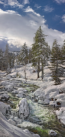
Location: North Yuba River, California State Route 49, east of Big Bend, CA
Created: 02/26/2017 9:40:22 am
Camera: EOS Canon 5D iii
Lens: EF 70-200mm 2.8L IS ii USM @ 70 mm
Aperture: f/18; 1/640 sec ; 3 shot vertical pano
This is one of my favorite year-round spots to visit, on the Yuba River, near Cisco Grove. The abounding wildness, on this February day, was captured after a substantial snowfall, during which the raging river was putting out it’s massive flow at over 23,000 cubic feet per second. This was one of the wettest years (2017) ever on record. The headwaters of this high elevation river in Tahoe National Forest drain from the Yuba Pass and its surrounding peaks. Running free, from the New Bullards Bar Reservoir, the Yuba River doubles in volume at the confluence of the Downie River. The Yuba is a major tributary to the Feather River, which eventually joins the Sacramento River, and provides abundant agricultural irrigation water to a hefty portion of the Central California Valley’s rich farmlands. It is said that the Yuba River got its name in the early 1900’s, from the wild grapes Spanish explorers encountered growing densely along the river bank. “Uva”, being the Spanish word for grape, transformed into its current designated name “Yuba”. The chameleon like charm of this region, to me, is the profound changes the seasons bring to it. In the later Fall months, in normal years, this section of river often flows at a mere five feet wide. For example, the massive waterfall in the lower portion of the photo, just adjacent to the huge jutting rock, becomes a calm juxtaposed pristine quiet cascade, with the flanking rocks covered in distinctly green blazing moss. It seems like visiting two completely unique worlds, each amazing, and each truly sensational.