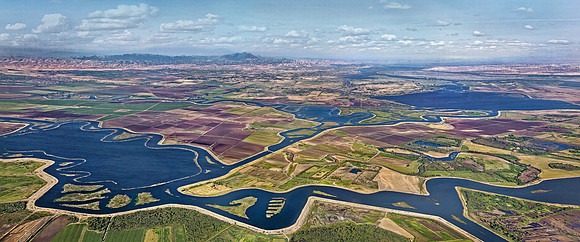
Location: San Joaquin Delta, CA
Created 05/01/2013 07:33:15 am
Camera: Canon EOS 7D
Lens: EF24-105 f/4.0L IS @ 24mm
Aperture: f/8 ; 1/2000; ISO 400; HDR pano; 8 shots; stitched in Photoshop
Imagine a verdant, marshy landscape filled with Tule Elk and Pronghorn Antelope cautiously grazing while keeping an eye out for the occasional Grizzly Bear wandering by. In the early-to-mid 1800’s, this scenic natural landscape was mostly marshlands, and was how the California Delta appeared to the 300,000 Native Americans who inhabited the land. Unencumbered by levees, the Delta freely pulsed and surged in large natural tidal swings, and was filled with a large variety of native fishes. Today, it is an entirely different place. The Delta is now a 738,000-acre, highly productive zone, that is created where two great rivers enter into slower-moving water influenced by Pacific Ocean tides. These rivers are the Sacramento River (flowing from the north); and San Joaquin River (flowing from the south). The modern landscape of the Delta is a myriad of islands maintained by dikes rather than levees. With the addition of subsidence, many of the reclaimed areas are now as much as 20 feet below sea level. This image was captured from a helicopter early on a cool spring morning. The small island, with several fingers cut into it, is at center in the lower section. This island was created by my grandfather, of which owned and operated a dredger to maintain the many fragile levees. This small island is so-called “five-fingers”, and was carved out to accommodate boaters to have a safe haven to dock boats, in the early 1900’s. Also, if you look to the far right side, you can see the 750 wind turbines near Rio Vista, some are over 250 feet tall; and on the left, near the Altamont Pass, there are over 4,000 turbines. Mount Diablo, rising 3,849 feet, is seen in the center. In the late 1700’s, "Monte del Diablo” which was described as a extremely dense thicket of willows at the north end of the valley; of which soldiers believed was possessed by evil Indian spirits, hence the given name,— Thicket of the devil. Acutely sensitive, the San Joaquin Delta is widely perceived to be in crisis today, “highly important, highly complex, and highly compromised”, and hopefully its ecosystem will continue to provide, survive, and thrive for many generations.